
Political Map WWII Mediterranean
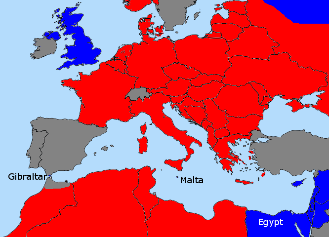
Political Map of the European and African theater during WWII. Red are Axis controlled lead by Germany, blue are Allied territories, gray are (officially) neutral (and light blue is ocean 😉 Emphasis is on Malta and Gibraltar as two key allied links in the Mediterranean Area. Map shows the greatest sphere of Axis influence around 1943. Front lines are not always precise, as the war was waging back-and-forth, but the big picture is correct. The political boundaries are modern.
 This work by Christoph Roser at AllAboutLean.com is licensed under a Creative Commons Attribution-ShareAlike 4.0 International License. Please credit the image as shown below. For digital documents and web pages please do include the links as shown below. Thank you.
By Christoph Roser at AllAboutLean.com under the free CC-BY-SA 4.0 license.
- File Name: WWII-Political-Map.png
- File type: png
- File size: 30.05 KB
- Dimensions: 666 x 480
- Date: August 30, 2014
- SEO Title: Political Map WWII Mediterranean
- SEO Description: Political Map of the European and African theater during WWII. Red are Axis controlled lead by Germany, blue are Allied territories, gray are (officially) neutral (and light blue is ocean ;) Emphasis is on Malta and Gibraltar as two key allied links in the Mediterranean Area. Map shows the greatest sphere of Axis influence around 1943. Front lines are not always precise, as the war was waging back-and-forth, but the big picture is correct. The political boundaries are modern.
- SEO Keywords: political Map, WW II, world war II, malta, gibraltar, Mediterranean, Europe, Africa
- Post or page attached: About the Value of Disagreement for Leadership, Visual Management during World War II – A Visit to the Lascaris War Rooms in Malta,